Re: Weglose Verbindungswege und Wege mit trail_visibility=no
Geschrieben von opasto (Gast) am 23. September 2013 20:33:16: [flux]
Als Antwort auf:
Weglose Verbindungswege und Wege mit trail_visibility=no
geschrieben von
unixasket
(Gast)
am
02. September 2013 16:50:
Ich habe an anderer Stelle (id=2625 Beitrag 1986) eine ähnliche Diskussion gestartet, deshalb hier die bis jetzt wesentlichen Inhalte:
Mein Beitrag:
In the swiss community I started a discussion on the use of paths with the tag sac_scale=difficult_alpine_hiking. To my opinion the use of such a path by "normal" people without "Mature alpine experience" and without "Familiarity with the handling of technical alpine equipment" could bring them into danger of life.
Now I found, that such paths in Lambertus maps are also handled like normal paths. My proposal: Let such paths away in the maps or show them with another layout.
Antwort von ligfietser
I would say when someone wants to do Alpine hiking better use more specialized maps.
Rendering it with another layout would be an option but unfortunately Garmin's default trail symbols are very limited without a typ file.
Meine Antwort:
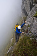
I agree with this. But nevertheless there are people in the alps who are very careless.
The basic problem is: What is a highway?? If you look to this picture
http://wiki.openstreetmap.org/w/images/ … ALE_T6.jpg
is this a highway?? It is from the definition page of sac_scale=difficult_alpine_hiking.
A solution could be to tag such a way not with ( highway=path & sac_scale=difficult_alpine_highway) but only with sac_scale=difficult_alpine_highway ,that means: delete the key highway=path. But this is in contradiction to the definition page of sac_scale, which states that sac_scale goes together with highway=path or highway=footway. To my opinion, there should be defined, that sac_scale=difficult_alpine_hiking is no highway and should be used only without the highway tag.